For a school project, you may not need your own book scanner: first check whether the map is already available digitally. The National Archives has put some of its map collection online; for public records, a scan in the reading room may be an alternative, subject to the archive’s conditions. If you’re scanning it yourself, measure the map or open atlas first, then choose between an overhead scanner and a flatbed scanner based on its size and condition. The University of Antwerp stresses the importance of preventing geometric distortion when scanning maps.
Who is this guide for?
A student with a large, loose map
You want to capture the whole map clearly, including its borders and legend. Measure the original and first check whether a digital version is already available; the National Archives has put some of its map collection online.
A student with a fragile atlas
You want to capture a map from a bound atlas without pressing the spine unnecessarily flat. The University of Antwerp’s scanning guidelines stress that maps should be digitised without geometric distortion. For fragile material, also check what handling is permitted.
A student comparing map details
You need small place names, symbols or distances for your analysis. Assess a test scan for legibility and distortion, not just the stated number of megapixels.
Which scanning option suits your map?
Existing archive scan or reading room
Choose this option when: the map you need is already online, or you can scan a public archive record for a one-off project.
Bear in mind: not every map is online, and you cannot photograph or scan records with restricted access at the National Archives. Book a place in the reading room in advance.
Contactless overhead scanner up to A3
Choose this option when: the map or open atlas fits within the stated scanning area and you’d rather not place the original under a lid.
Bear in mind: an overhead scan can still be skewed or distorted, and A3 isn’t large enough for every loose map.
A3 flatbed scanner designed for books
Consider this option when: an atlas page fits on the scanning bed, can rest safely on the glass, and details close to the spine are important.
Bear in mind: the original rests on the glass, so this approach isn’t automatically suitable for a fragile binding or an oversized map.
Professional large-format or archive scanner
Look into this option when: the whole map is larger than A3, or a fragile bound original needs specialist support.
Bear in mind: the Dutch supplier describes the book2net Kiosk Public as an A2 scanner with a scanning area of up to 460 × 645 mm. Check whether the facility suits your project.
| What to consider |
What to look for when buying |
Who this matters most to |
| Capturing the whole map in one scan |
Measure the map, including any borders you need, and compare its size with the scanning area of the exact model. CZUR states that the Shine 800 A3 Pro supports up to A3. |
I want to capture the entire map, including its legend and borders, in one image. That’s why around 33% of consumers prioritise the full scanning area. |
| Handling the original with care |
Check what handling is permitted and whether the original can safely rest on glass or should be scanned without contact. If you’re considering a book cradle, check that the necessary support is available. |
If my atlas is fragile, I don’t want to press the spine unnecessarily flat. That’s why around 25% of consumers prioritise careful handling of the original. |
| Legible details and accurate proportions |
Check a test scan for small lettering, lines and distortion. Don’t compare sensor resolution directly with software-interpolated resolution. |
Place names and map proportions need to remain useful for my analysis. That’s why around 25% of consumers focus on legible details and geometry. |
| One-off use |
First look for an existing digital map and check the scanning conditions in the reading room of the relevant institution. |
For a single school project, I want to know whether buying a scanner is really necessary. That’s why around 17% of consumers first consider the archive options available. |
Pitfalls to avoid when buying a scanner for historical maps
-
Assuming A3 will fit every map
A map that’s larger than the scanning area won’t fit completely in a single scan. A partial scan won’t automatically give you a complete image of the map.
Measure the map, including the borders you need, before choosing a model. For a larger original, look into an archive or professional large-format scanning service.
Looking for a discontinued model can take extra time.
Brands and models as examples
These examples show different approaches to scanning. The features mentioned apply to the models described and aren’t general recommendations for any brand.
CZUR
The Shine 800 A3 Pro is a foldable overhead scanner for originals up to A3.
- CZUR lists an 8MP sensor and output formats including JPG, TIFF and searchable PDF for this model.
- CZUR states a resolution of 205 dpi at A3. This manufacturer specification doesn’t prove that fine details on every historical map will be legible.
IRIS
The IRIScan Desk 7 Pro is an overhead scanner for documents up to A3, with OCR output.
- According to IRIS’s model comparison, the Desk 7 Pro has an 18 MP sensor resolution and supports options such as TIFF and searchable PDF.
- The stated 85 MP is software-interpolated, not the sensor resolution. These product specifications aren’t an independent quality test.
Plustek
The OpticBook A300 Plus is an A3 flatbed scanner with a design geared towards books.
- Plustek describes a book-edge design and output formats including TIFF and searchable PDF.
- The original has to rest on the glass. This specification alone doesn’t tell you whether a particular fragile atlas can be scanned safely.
book2net
The Kiosk Public is a professional A2 self-service scanner, described by a Dutch supplier for use in libraries and archives.
- The supplier lists a book cradle, USB storage and a scanning area of up to 460 × 645 mm.
- The V-shaped adapter is an additional option. Check that the facility and support are suitable for the original.
Epson
The Expression 13000XL and WorkForce DS-50000 illustrate the A3 flatbed approach, but Epson Netherlands lists both models as discontinued.
- Epson listed A3 scanning for both models.
- As they’re discontinued, they aren’t obvious current buying options. Check the status of the exact model.
Joybuy products for this topic
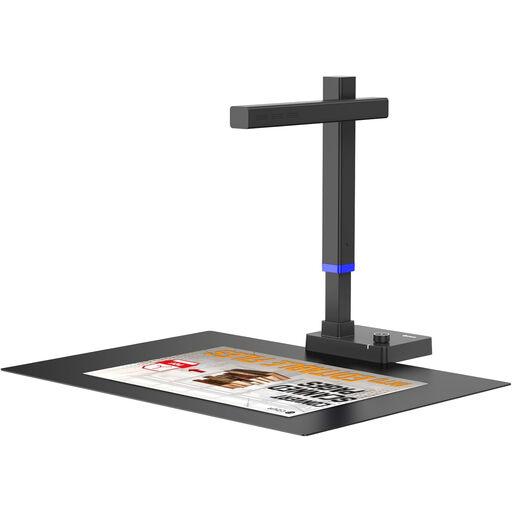
This Joybuy selection is for overhead scanning of maps that fit within A3.
 No image available
CZUR Shine 800 A3 Pro document scanner
Suitable for maps or atlas pages that fit within the stated A3 size, if you’re looking for an overhead scanner.
The product information lists an 8MP CMOS sensor, OCR and compatibility with Windows or macOS. CZUR states that this model supports up to A3 and lists a resolution of 205 dpi at A3. These are manufacturer specifications, not a guarantee that every map detail will be legible.
The product information describes a foldable design and a stable base for use. It isn’t recommended for glossy materials.
View at Joybuy
Frequently asked questions
Do I need to buy a scanner if the map is from the National Archives?
Not necessarily. Some map collections are available to view online. The National Archives also allows visitors to scan public archive records in the reading room. Book a place in advance and check the conditions for the record you need.
How can I stop a folded map or atlas from appearing skewed in the scan?
Only flatten and stabilise an original as far as the conditions of use allow, and don’t force it. For an overhead scan, check the camera angle and look at a test scan for curved lines or distortion around folds or the book spine. Automatic correction doesn’t guarantee geometric accuracy.
Which file format is useful for a map with small place names?
Check whether the exact model can save an image file for visual inspection and, if needed, a searchable PDF for text searches. For the Shine 800 A3 Pro, CZUR lists formats including JPG, TIFF and searchable PDF. Check small place names in the image itself too.
How can I tell whether an A3 scanner is large enough?
Measure the entire map or open atlas, including the borders you need, and compare the dimensions with the scanning area of the exact model. An A3 specification doesn’t mean every historical map will fit in a single scan.
Can I scan a historical map and put my school project online?
No. Don’t assume you can publish it freely just because the map is old or you’re scanning it for school. The Dutch Government distinguishes between making a copy for personal use and distributing or publishing it. The National Archives allows free reuse of its downloadable scans marked ‘Public Domain’ or ‘CC0’. For other maps, check the applicable rights and conditions. Visitors may not take their own photos or scans of records with restricted access at the National Archives.